
Trace a Lower Macungie Township Street
A Lower Macungie Township street directory search is a chain of address records. Begin on the county property card, then use the map and Recorder index only when each result matches the same parcel. This method identifies recorded owners and property history. It cannot turn a street search into a complete list of people in every home. Keep notes for each lot so similar street names and changed addresses do not become mixed together.
- Enter the address in Lehigh County Property Search and save the PIN, property address, owner mailing address, and sale document ID.
- Open the parcel in the County Parcel Viewer and note adjacent parcels and mapped boundaries.
- Use the document ID in the Recorder of Deeds path, then inspect the grantor, grantee, date, legal description, and instrument or book-and-page reference.
- For older address questions, search both current and former road names, along with the PIN or legal description.
- When the question concerns a historic household, ask the library or archives for the date-specific record rather than inferring it from the current parcel card.
Lower Macungie Township Street Search Fields
The county form behind the Lower Macungie Township street directory is deliberately address based. It accepts an Address, a Parcel Identification number, or a Document ID/Instrument Number. Search text must be four to 30 characters with no special characters, and the public form requires a CAPTCHA. Street-direction choices include E, N, NE, NW, S, SE, SW, and W, while its suffix glossary recognizes forms such as Avenue, Boulevard, Circle, Court, Drive, Lane, Parkway, Road, Street, Terrace, and Way.
| Search control | Lower Macungie Township use |
|---|---|
| Address | Starts a current street-by-street property search. |
| Parcel Identification | Uses a 12-digit PIN, with an optional PAR number after a space. |
| Document ID | Connects a property-sale reference to the relevant record trail. |
| CAPTCHA | Required before a public search is submitted. |
The Township Streets and Sidewalks Appendix is a useful companion when the address has a former road name.
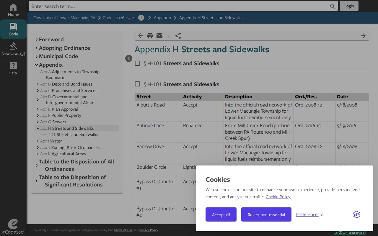
Use the county search for the parcel, then use the road appendix to translate a historical search term if the current spelling does not return a result.
Lower Macungie Township Parcel Map
The Parcel Viewer adds the geographic layer to a Lower Macungie Township street directory lookup. Its public parcel service supports spatial and distance queries, pagination, and map geometry. On the map, select the parcel, record its PIN and situs fields, and use the property record for the ownership and sale details. A mapped line helps locate a tax parcel, but a recorded plat, survey, or deed legal description is the correct source when an exact boundary matters.
The viewer’s Buffer Report accepts an address or PIN and begins with a 100-foot buffer. It is a practical way to identify potentially adjacent parcels around a street location. Each returned parcel still needs its own card check. A buffer is a map measurement, not proof of a personal connection, shared household, or property boundary.
Note: Map results are best treated as a parcel-finding tool before moving back to the county property card and recorded document trail.
Lower Macungie Township Address Records
Each address record answers a narrower Lower Macungie Township street directory question. The property card joins recorded ownership and assessment facts to a situs. GIS maps show parcel geography. Recorder material supplies dated parties and legal references. Township permit files can document a project or review, but no public permit-by-address database was verified. The records complement one another only when their parcel and date details agree.
| Address record | Keeper | Street-related detail | Access channel |
|---|---|---|---|
| Assessment property card | Lehigh County Assessment | Owner mailing and situs address, PIN, assessment, sale row | Free Property Search with CAPTCHA |
| Parcel map | Lehigh County GIS | Parcel footprint, PIN, municipal context, nearby parcels | Parcel Viewer and public service |
| Deed index | Recorder of Deeds | Document parties, date, instrument, legal references | LANDEX, county access, or counter |
| Permit and zoning records | Lower Macungie Township | Existing application, review, inspection, or approval material | Permit Department or focused RTKL request |
| Historic tax and assessment layers | State Archives | Taxpayer and parcel context in documented periods | Archive inventory and research route |
- Situs address
- The physical property address used by the assessment record, distinct from the owner’s mailing address.
- PIN
- The county parcel identifier used to keep a Lower Macungie Township search tied to one property.
- Plat
- A recorded map or plan that may define lots and boundaries more precisely than a screen map.
- Criss-cross directory
- An older directory arranged by address rather than solely by a person’s name.
Lower Macungie Township Deeds by Street
A property card’s sale-history row can include the document ID that bridges a Lower Macungie Township street directory search to the Recorder of Deeds. In the recorded instrument, check the party roles, document type, recording date, legal description, and parcel reference. The seller on the current transfer may be the buyer on the prior transfer. Repeat only when the legal description remains the same, because the same name can appear on unrelated properties.
Lehigh County describes LANDEX coverage from 1812 to the present and a Russell index sequence for 1812 to 1983. For older material, the Recorder counter and Pennsylvania State Archives are documented channels. The Recorder office is in Room 122 at the Lehigh County Courthouse, 455 W. Hamilton Street, Allentown, with weekday Recorder hours of 8:00 a.m. to 4:30 p.m. Its staff cannot conduct a search or give legal advice.
Lower Macungie Township Road Name Bridges
Historical street work needs Lower Macungie Township’s real name changes. Center Jackson Road became Millbend Road on February 9, 1961. Parts of Mill Creek Road and Mill Creek Spur changed to Antique Lane and Mill Creek Road on May 19, 2016. Part of Schoeneck Road became Dragonfly Lane on September 21, 2017. Service Road One became Charcoal Drive on May 18, 2023, and Service Road Two became Hamilton Circle on June 5, 2025.
When a current address produces no older result, repeat the search with both names, the PIN or PARNUM, legal description, and nearby-road references. Many early roads were not named until well into the twentieth century. A stable parcel or description can survive a renamed road far better than a current street label.
Lower Macungie Township Permit Fallback
The Township requires zoning permits for specified construction, reconstruction, expansion, conversion, structural, grading, and use changes. Its Permit Department receives complete submissions, conducts plan review, and schedules inspections. Since there is no verified public address lookup for permits, the useful Lower Macungie Township street directory fallback is a specific request for existing permits, certificates of occupancy, inspection records, enforcement notices, or approved plans for a named address and date range.
Send a focused request to the township’s Right-to-Know Officer through the current Right-to-Know instructions, by the documented email, mail, fax, or in-person channel. The request should seek records that already exist. A permit can identify an owner, applicant, architect, or contractor in a project record, but it does not prove that a person lived at the location.
Lower Macungie Township Street Voter Limits
Pennsylvania provides specialized voter-list products under its Election Code, but the ordinary status page is not a Lower Macungie Township street directory. The public form directs a voter to check their own status. A Street List and Walking List have statutory access, purpose, and publication restrictions that must be confirmed with the current custodian. The Lehigh County Voter Registration office is the local contact at 610-782-3194.
Registration information does not disclose individual ballot choices. Protected registration and address-confidentiality circumstances require withholding, and a street file should never be republished as a neighborhood record. Use the property and parcel route for address work, then seek voter information only through the lawful official channel.
Lower Macungie Township Street Card Details
Read each Lower Macungie Township property-card result as a small record inventory, not as a roster. In addition to the owner name and owner address, the county’s inspected result layout can show the property address, low and high street numbers, tax authority, school district, Parcel ID, old Parcel ID, subdivision, acreage, dimensions, utilities, class, land use, zoning, homestead status, building features, and sale history. Sale history may provide a sale date, indexed owner, document ID, and sale price.
Those fields are useful when addresses shift or a long street crosses subdivisions. The Sub Division field, legal description, and old parcel ID can identify the same tract under a different road reference. Homestead Act 72 status is an assessment and tax-relief field. It is not a household census. Likewise, a sale row is a valuable bridge to the Recorder index but is not a full title abstract. Inspect the recorded document before drawing a conclusion about the property’s earlier chain.
A street-by-street search becomes more reliable when each result is logged with its exact property address, PIN, old parcel ID, document ID, and record date. That small trail prevents an older address, a similarly named owner, or a neighboring parcel from being folded into the wrong Lower Macungie Township street record.
Lower Macungie Township Historical Streets
For historic Lower Macungie Township street questions, move beyond the current card when the search reaches a farm parcel, old village label, or former township name. Lower Macungie Library’s Local History and Genealogy Center has non-circulating local reference material, church and cemetery genealogical records, yearbooks, and photo and document files. Its scope includes Lower Macungie Township, Macungie, surrounding areas, Lehigh County, and eastern Pennsylvania. Staff can help identify a relevant record type, but the public pages do not publish a verified reverse-directory or city-directory year run.
Allentown Public Library’s microfilm collection has regional City Directories for 1860 to 1980, Morning Call material, an obituary index, and census microfilm. The Lehigh County Historical Society also reports regional directories, maps, deeds, tax material, wills, and census resources. A nearby directory entry can be a strong lead for a Lower Macungie Township street, but the volume must be inspected for coverage before it is treated as evidence. For the historical collection method, use the city-directory route rather than rebuilding the library shelf from a current address search.
State Archives tax books from 1846 to 1890 and assessment records from 1891 to 1945 are additional address-history layers. They can connect a taxpayer or parcel context to the period before a current street identity existed. Search the older Macungie Township label for records that predate the 1832 division into Lower and Upper Macungie.
Limits of a Lower Macungie Street Directory
A Lower Macungie Township street directory can show recorded parcels, owners, dated documents, and some historical context. It cannot establish every current household member, private utility customer, protected address, or a complete list of people on a road. The owner mailing address and the physical property address can differ for many legitimate reasons. The correct result may be a documented no-match or a referral to the custodian rather than a guess.
Lawful personal research only. Use Lower Macungie Township address records for family history, a property question, civic research, or another lawful purpose. Never use a street search to stalk, harass, intimidate, or harm anyone.